ALTOONA SUBDIVISIONS
When hearing the word subdivision, our minds generally drift to the rise of suburban America after World War II—cookie-cutter houses, green manicured lawns, and a distinctive shape or pattern to the subdivision layout. It would be almost impossible to apply this definition to Altoona. However, as defined by the Oxford English Dictionary, a subdivision is “the act of dividing a part of something into smaller parts.”[1]
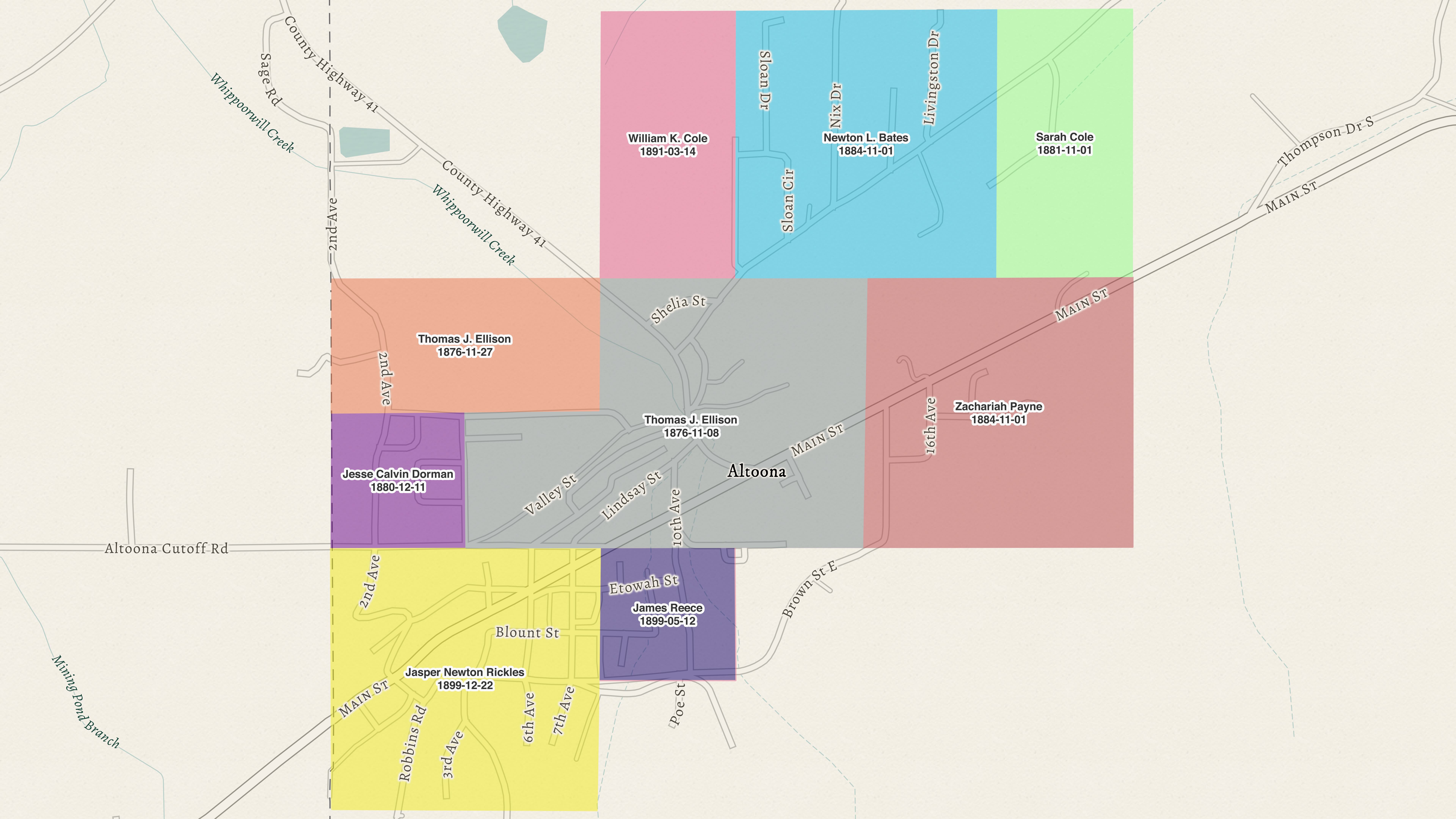
Altoona was conceived during a May 1900 meeting between Jasper Rickles and W. T. Underwood. After prospecting Rickles’ property on Blount Mountain and returning to Birmingham, Underwood and his associates incorporated the Underwood Coal Company. At this point, what was to become Altoona was owned by a handful of large property owners: Jasper Rickles, Thomas Ellison, William Cole, Sarah Cole, Zach Payne, Newton Bates, James Reece, and Jesse Dorman. Over the course of the next decade, these large tracts of property would be transformed into Altoona’s subdivisions.
Applying the true definition to Altoona reveals fifteen different subdivisions within the town. The purpose of this essay is to explore each of these subdivisions, the purpose and history behind their creation, and the men whose property was subdivided. While Altoona was conceived as a mining town, this study will reveal that, through foresight and planning, it evolved into a community that extended beyond the exploitation of the surrounding mountain’s mineral wealth.
WHICH WAS FIRST?
There is some question regarding the first Altoona subdivision. Chronologically, the title belongs to the East Altoona Addition, which was surveyed on November 15, 1900. [2] However, in a 1922 news article, Jasper Rickles states that he “laid off the first lots in Altoona, known as Rickles Addition No. 1. Later, he laid off No. 2. Then the Culverhouse Addition No. 3 came into existence (East Altoona). The first lot in Altoona was bought by Bill Debtor.”[3]
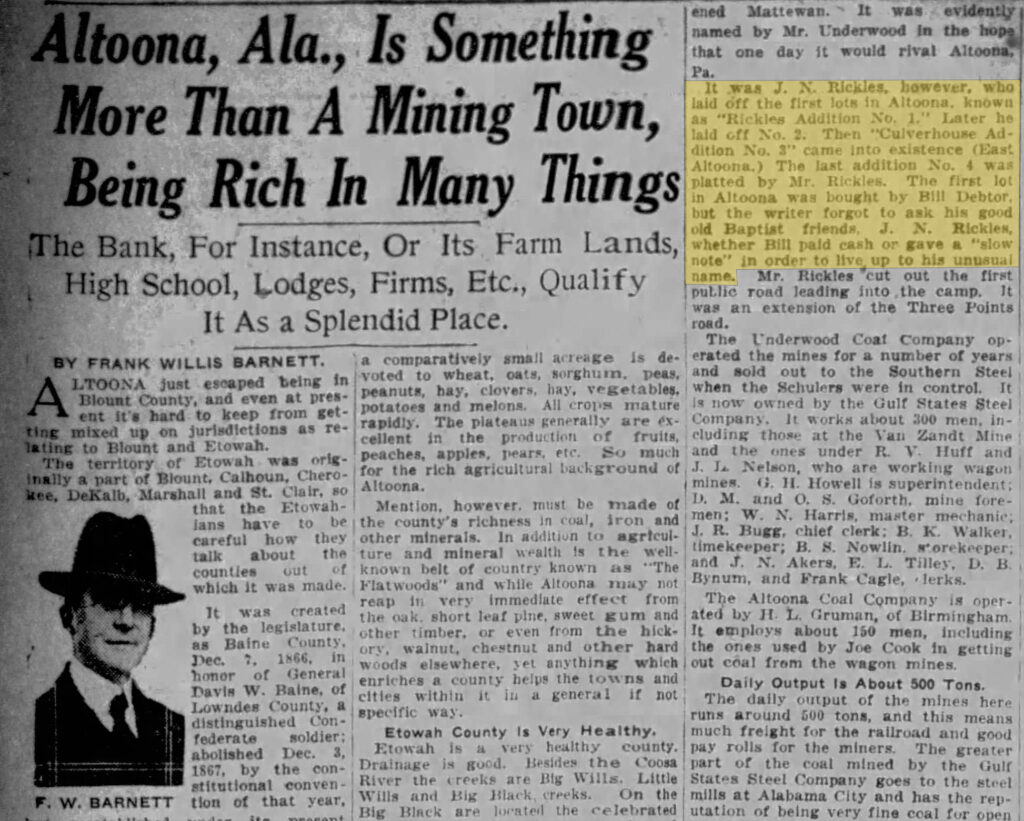
Unfortunately, Rickles Addition No. 1 was not recorded until 1905, followed the same year by Rickles Addition No. 2. This discrepancy may have been due to the passage of time, given the span of nearly twenty years between the founding of Altoona and the article. This is supported by the fact that after East Altoona, the next subdivision—the Payne Addition—was established three years later, in early 1904.[4] Rickles’ recollection does not include the Payne Addition at all. Bill Debtor’s deed record would clarify any discrepancy, since Rickles may have sold lots before recording the subdivision.[5] Unfortunately, a deed attributed to Bill (William) Debtor does not exist in the Etowah County Deed Records.
TOWN BUILDING
Details also emerge in the name itself. Since the East Altoona Addition was the first to be recorded (by three years), why was it named East Altoona? This could indicate that other subdivisions were planned at the same time as East Altoona, which would verify Rickles’ 1922 statement. However, upon closer examination, this does not appear to be the case. So why was the first subdivision called East Altoona? A review of early records and the nature of New South coal towns provides the answer.
What began with the settlements of Balm and Nix set the foundation for Altoona. Just as many men from these areas went on to early leadership and business positions within the town, the landowners in what would become Altoona prior to 1900 also seized the opportunities before them. Rickles, Jesse Dorman, Zach Payne, and B. H. Dorman were all early landowners who later subdivided their properties into lots and blocks. The fuel for a new town was present, but what was needed was a spark to set it in motion. This spark came in the form of W. T. Underwood and the Underwood Coal Company. Thus, Altoona, at its conception, was a coal town. Each of these subdivisions, and the town of Altoona itself, came second to the original “Altoona,” the name given to Underwood’s mining camp.[6]
For all intents and purposes, the mining camp created in May 1900 became Underwood’s “company town.” Underwood planted the settlement; his company built the houses and the company store. At that time, “the camp” was largely centered in the area Altoona residents know as “the camp” today—the area lying between 7th and 10th Avenue. It was here that the original seventy-five mining houses were constructed during the summer of 1900.[7]
Underwood set out not as a town builder, but as a coal operator. His interest was the mineral wealth in the area and his company’s duty to bring it to market. This is reinforced by the fact that the first subdivision was not recorded until mid-November 1900—not by Underwood or the coal company, but by Superintendent Franklin Culverhouse, who personally purchased the property.[8]
Another indication of Underwood’s intent comes from the site of his company store, which was located adjacent to the depot lot. [9] Both structures were near the intersection of 10th Avenue and Brown Street, on the edge of the camp. The company store also housed the first post office, with the earliest postmasters also serving as commissary clerks.[10] The location of these buildings within the camp—not on Culverhouse or Rickles property—reinforces the conclusion that Underwood’s intent was not to build a town.
Despite his intent, Underwood did not attempt to rule the camp or the growing settlement with an iron fist. In fact, he allowed both outside businesses and individuals to have considerable influence on the community. In 1902, Underwood wrote to his brother Oscar regarding issues with the post office:[11] “Wont you do us a favor to see if something can not be done to induce the P.I. Department to pay for carrying mail between Altoona & Oneonta? We now have a growing town of six or seven hundred people in and about Altoona, & there can be no reason why the government should not pay the expense of giving there people a daily mail instead of our company. I think the Walnut Grove mail aught to be sent up to Altoona by train every evening instead of being put off at Oneonta, staying all night there, and going by here to Walnut Grove the next afternoon.”
Again, Underwood shows his primary interest in his company by stating that the government—not the Underwood Coal Company—should bear the cost of delivery. However, he also acknowledges the growing town and suggests that Walnut Grove’s mail be routed through Altoona. Underwood does not appear discouraged by the town’s growth; rather, he sees it as an opportunity to shift a financial burden from his company to the postal service.
Ethel Ames, in The Story of Coal and Iron in Alabama, states the following about Underwood’s relationship with Altoona: “He gave the people, both in and outside of his camp town, schools and churches, encouraged them to establish lodges of Odd Fellows and Masons, and helped them in many ways.”
There is circumstantial evidence that Underwood supported the school. The 1989 reunion booklet mentions that the original schoolhouse was located within the camp. [12] Unfortunately, no record of such a school has been found. The first documented school was located at the present site of Fuel City, with county payroll records indicating it was a public school as early as March 1902.[13] However, there is no record of Rickles or Ellison deeding this property to Underwood. The schoolhouse was also used as the miners’ union hall and as a meeting place for fraternal orders.
The earliest fraternal orders in Altoona—the Odd Fellows and the Masons—were both organized in 1904. While the Masonic lodge was known as the W. T. Underwood Lodge, Underwood himself does not appear as a member. Likewise, both Methodist and Baptist church histories record that, prior to constructing their own buildings, congregations met in the schoolhouse. The Methodist church originated in 1903, followed by the Baptist church in 1904,
After establishing his company, shipping coal, and witnessing the beginnings of a town, did Underwood shift his focus to town building? In a 1904 letter to his brother Oscar, Underwood mentions “little storekeepers” circulating petitions to have themselves appointed postmaster. [14] He later describes them as unsuitable for Altoona. Without further context, this letter could be interpreted in several ways. Was his criticism aimed at preventing the post office from moving outside the company store? Or did it reflect a desire to see someone appointed who would benefit the town as a whole? The motivations of the storekeepers themselves must also be considered. Were they attempting to move the post office outside the mining camp? In the end, Underwood prevailed, and the post office remained at the commissary for another decade.
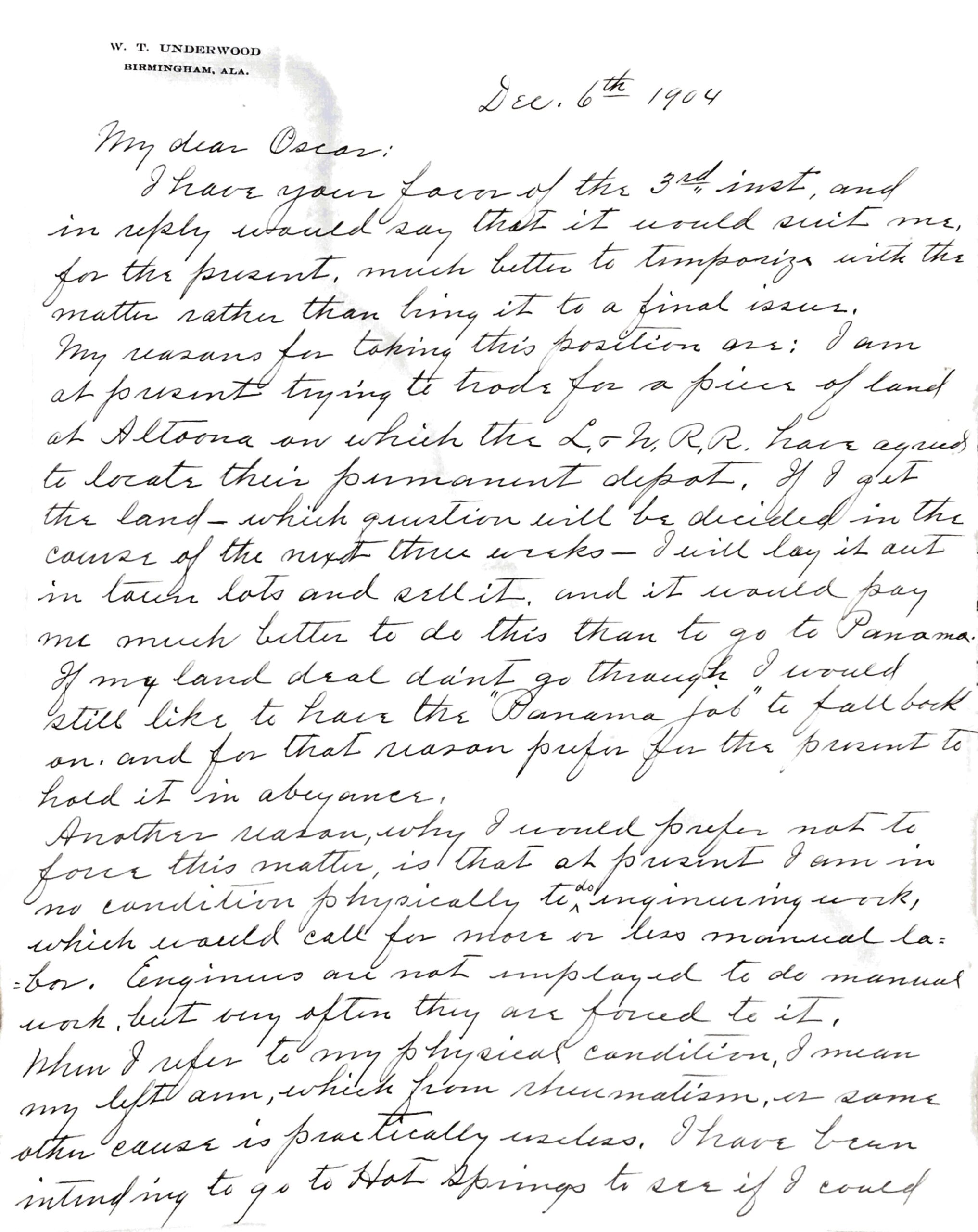
What about his encouragement of fraternal societies, churches, and other civic activities typically associated with a town? Underwood never made Altoona his permanent residence. While he frequently stayed there, his permanent home and family remained in Birmingham. Although he may have offered verbal or financial support for religious, fraternal, and social organizations, none of the relevant properties appear to have passed from his ownership to private individuals or organizations. By October 1904, Underwood’s time in Altoona ended with the Despite the sale, Underwood’s younger brother, Eugene Underwood, remained in Altoona. During the winter of 1904, Oscar Underwood, a United States senator, encouraged Eugene to go to Panama to work on the Panama Canal. In a December 1904 letter, Eugene declined:[15] “I am at present trying to trade for a piece of land at Altoona on which the L.&N. R.R. have agreed to locate their permeant depot. If I get the land – which question will be decided in the course of the next three weeks- I will lay it out in town lots and sell it. And it would pay me much better to do this than to go to Panama.”
Eugene was successful in acquiring the property and began laying out lots. In a second letter, written in the spring of 1905 to W. T. Underwood, Eugene requested assistance in securing telephone service: “The Southern Bell Telephone Co. are putting up a line from here to Gadsden and I learn that Crump and Walker are trying to get these people to locate their office at or near their stores. Can you find out who the manager of this company is, and drop him a line calling his attention to the fact that the depot will shortly be moved, and ask you to consider the desirability of locating his office near the depot. I think likely some of the officials of the company have their offices in Birmingham”.
Like W. T., Eugene used Altoona to further his personal goals. Yet, in doing so, he also advanced the town’s development. Just as Eugene relied on his brother for assistance with Southern Bell, W. T. had relied on Oscar for help with the postal service. The Underwood family was exceptionally well connected, and—whether intentionally or not—these connections helped transform Altoona from a mining camp into a town.
However, there is one key difference between W. T. and Eugene Underwood. W. T.’s Altoona could have thrived without becoming an organized town. He did not require schools, churches, or civic institutions for his mining operations to succeed. Eugene’s ambitions, however, depended on Altoona becoming a viable town. Without social and civic development, he would have been unable to sell lots, and his investment would have failed. Yet Eugene’s opportunity was made possible by W. T.’s earlier success, which provided the foundation for further development.
Eugene, like Culverhouse, Rickles, Payne, Ellison, and others who subdivided their land, were the true town builders. They enabled private enterprise and settlement to transform Altoona from a mining camp into a thriving community. However, their success ultimately traces back to Underwood. While he may not have intended to build a town, he did not hinder its growth. His approach resulted in both a successful company and his recognition as the founder of Altoona.
Several years after leaving Altoona, Underwood reflected on the region before his arrival and its subsequent development.[16] His remarks summarize his role in Altoona’s history: “In the spring of 1900, I have secured control a body of coal lands in western Etowah and Blount Counties, and wanted to open mines. I wanted it badly, but my lands were many miles from a railroad…I then went to Mr. M.H. Smith and found no difficulty in arousing his interest in it…He then arranged with a Louisville bank to loan my company many thousands of dollars, which we were allowed to pay off from our earnings. He began building twelve miles of road for us in May, 1900, and in the following October we were shipping coal over it…the country through which he built the (rail)road, and its extension on to Atalla, had been almost a wilderness. The population there has now increased ten times or more, and the city is prosperous. Other railroads had been asked to do this but they did not. Had it not been for Mr. Smith’s desire to extend the sphere of usefulness of his road, hie comprehensive understanding of businessmen and their needs, as well as of railroads, and his personal inclination to help men with good propositions, that section of Blount and Etowah counties would still be asleep. To-day, and for fifty yean to come, its mines can give a living to many thousands of people… The prosperity of the people of the Alabama mineral district is very largely due to the liberal policy of M. H. Smith.”
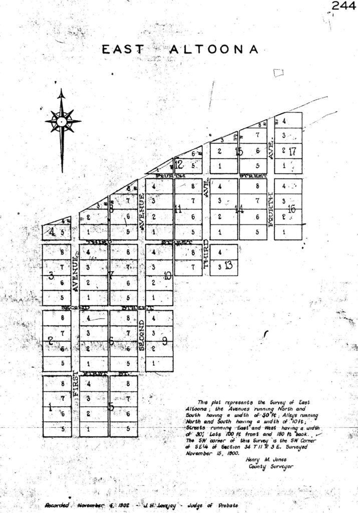
EAST ALTOONA ADDITION
The area that became Altoona’s first subdivision, the East Altoona Addition, remained government property until 1884, when it was obtained by Zachariah Payne.[17] The property remained in Payne’s possession until October 1900, when it was transferred to J. B. Harris.[18] Harris, in turn, deeded the property to Frank Culverhouse later that same month.[19]
There is some confusion within these deed records. The deed from Payne to Harris was executed on October 27, 1900, for $475, while the deed from Harris to Culverhouse was executed on October 13, 1900, for $295. Aside from the obvious issue of the document dates in relation to the transfer of ownership, the fact that Harris sold the property at a loss to Culverhouse is also peculiar. Aside from a ten-acre difference—which Harris retained and later sold to Culverhouse—both descriptions are the same. The most plausible explanation is some form of gentleman’s agreement between Harris and Culverhouse relating to the future platting and sale of lots in the East Altoona Addition.
While the mining camp and commissary were company property, the East Altoona Addition represented the first development independent of the company. East Altoona is composed of 167 lots. Early deeds reveal that the subdivision was used not for residential settlement, but for commercial and business purposes. A Dun’s record from September 1901 lists two Altoona businesses—Hamilton & Starkey and M. F. Walker and Sons—both operating out of East Altoona. Later records show additional business owners, including I. S. Cook, Pizitz, James Wheat, and Sam Baker.[20]
The absence of residential ownership is notable, but not alarming. Some individuals, such as Wheat and Starkey, were in the area prior to the development of the Underwood mines and took advantage of the opportunity as business owners. Others, like Baker and Pizitz, had established businesses elsewhere and capitalized on the opportunities afforded by the Underwood mines. It is likely that some families lived behind or above their businesses, a detail not reflected in property records.
East Altoona’s role as the primary business district was short-lived. By 1905, lots along present-day 7th Avenue (Rickles Addition No. 1) were being purchased and developed. Some individuals who operated businesses in East Altoona purchased residential lots in Rickles Addition No. 1 as early as 1902, demonstrating the flexibility of that subdivision as both a residential and commercial area.[21] With the construction of the first municipal building and the First State Bank in 1908 and 1909, the transition away from East Altoona as the primary commercial district was complete.
As a result, East Altoona became increasingly residential. By 1910, thirty-five families resided within the subdivision, though only six owned the property on which they lived.[22] Five of these were East Altoona property owners prior to 1904.[23] Cross-referencing census data with ad valorem tax records reveals several familiar names, including Sam Baker, W. D. Debtor, James Wheat, H. L. Starkey, and R. D. Stanfield. In contrast to the census, the ad valorem records list a total of nineteen property owners in East Altoona, including Culverhouse, who still owned most of the property. This indicates that while businesses relocated, property owners retained their lots and became landlords.
The remaining twenty-nine families rented from these landlords, but that is only part of East Altoona’s transition. Of these twenty-nine families, ten were white and nineteen were Black. East Altoona was well on its way to becoming a predominantly African American neighborhood. While the census lists all Black residents as renters, the ad valorem records show that Grant Bradford was an African American landowner in East Altoona.
PANA
The area known as Pana has been a mystery for years. On publicly available maps, Pana first appears on the 1920 Birmingham Mineral District Railroad and Mine Map. [24] It is also found on the 1937 Etowah County Highway Map and subsequent editions through the present day. Interestingly, Pana does not appear on the 1958 or 1975 editions of the 7.5-minute quadrangle map, but it does appear on the 2014 edition. These maps place Pana more than a mile east of East Altoona, in the large curve between Thompson Cutoff and Ashville Road.
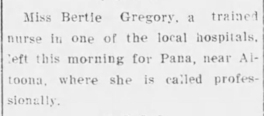
Outside of cartographic references, Pana is first mentioned in a 1908 Gadsden Times article: “Miss Bertie Gregory, a trained nurse in one of the local hospitals, left this morning for Pana, near Altoona, where she is called professionally.”[25] It is also referenced in a 1909 Southern Democrat article: “Jim Wheat has moved a nice stock of goods from Pana (East Altoona) to Altoona.”[26]
Dr. James P. Jolly, in The Place Names of Calhoun & Etowah Counties, Alabama, states that Pana was named because “J. B. Pana and family lived here by 1870.” An examination of deed records indicates this is incorrect. Jacob Robbins obtained the original property from the U.S. government in the 1850s, and no individual with the surname Pana appears in the chain of title. Additionally, the surname does not appear in any Etowah County deed records.
The most plausible explanation for the name Pana relates to the influx of African American residents into East Altoona. The name is associated with the Pana Riot of 1899, which took place in Pana, Illinois, when coal operators attempted to break a strike by employing Black miners from Alabama. Whether Altoona’s Pana was named by miners who had been in Illinois or reflects a similar labor dynamic is unknown.
Why later maps place Pana more than a mile east of East Altoona remains unclear. Both newspaper references can be directly tied to East Altoona. A 1917 L. & N. right-of-way map correctly places Pana at East Altoona.[27] One possibility is that mapmakers were given descriptions such as “East Altoona” or “one mile from Altoona in East Altoona” and, not recognizing East Altoona as a subdivision, interpreted the description literally. Over time, this misplacement became fixed in subsequent maps.
LATER DEVELOPMENTS
By 1920, East Altoona was well established, and its later history is best understood within the broader context of Altoona’s African American community. Due to segregation, however, East Altoona often functioned as a semi-independent section of the town.
In 1916, Alex Hays, Alonzo Williams, and Charles Miller organized a Methodist Episcopal church.[28] Although the church was not located within the East Altoona Addition, its property adjoined the subdivision. By 1968, it was known as Hays Chapel Methodist Church.[29] By the 1990s, the building had fallen into disrepair and was destroyed by the 2001 tornado.
In 1918, R. D. Stanfield and his wife sold a lot to the East Altoona Colored Baptist Church, pastored by J. T. Thornton.[30] n 1971, the church was renamed Greater East Side Baptist Church under the leadership of Rev. William Lee Perkins. [31] he church was also damaged in the November 2001 tornado but was rebuilt and remains active today.
East Altoona was also home to a Masonic lodge. Golden Reed Lodge No. 119 A.F. & A.M. obtained a lot from T. R. and Pinkie Bynum.[32] A 1916 deed lists Alonzo Williams, Grant Williams, Jonah Brown, and T. L. Bryant as trustees.
In 1949, water was expanded to East Altoona, with further expansion occurring between 1954 and 1955.[33] During this period, the name “East Town” was first used to describe East Altoona—a name that persists today.[34] In July 1955, the town borrowed $5,000 to purchase 3,200 feet of pipe to complete the system. [35]
East Altoona was also the site of a school. Due to segregation, a separate school (serving grades one through six) was located at the end of Rogers Road. Constructed in 1917 with assistance from the Rosenwald Fund, the school was a one-room frame structure.[36] Water was supplied by a hydrant, and sanitation consisted of an outhouse.[37] The school featured a milk program, a small library of 125 books, and an old piano. In 1958, enrollment was eighteen students under the instruction of veteran teacher Cora P. Jennings. Following desegregation, students were consolidated into Altoona High School and West End High School. The building was later moved across Highway 132, where it remains as a private residence. Only foundation remnants remain at the original site.
In the early 1960s, four units of public housing were constructed on Brown Street in East Altoona. These units were damaged during the 2001 tornado but remain in place today. In 1968, the town council approved paving the portion of Brown Street extending from Highway 132 past the housing units to Eastside Baptist Church.[38]
CONCLUSION
The history of the East Altoona Addition provides a focused lens through which the broader development of Altoona can be understood. What began in 1900 as a mining camp under the direction of W. T. Underwood quickly evolved into something more complex, shaped not by a single vision of town building, but by overlapping and sometimes competing interests. Underwood’s priorities remained firmly rooted in coal production, yet his actions—establishing the camp, constructing infrastructure, and leveraging regional connections—created the necessary conditions for a town to emerge.
Within that framework, East Altoona stands as the earliest clear expression of development beyond company control. Platted and recorded at the very outset of Altoona’s existence, it functioned initially as a commercial district, housing many of the town’s earliest businesses. Its rapid transition, however, underscores the fluid nature of early Altoona. As commercial activity shifted westward to Rickles Addition No. 1 and other developing areas, East Altoona adapted, becoming a residential community and, by the early twentieth century, a predominantly African American neighborhood. In this transformation, it reflects both the internal evolution of Altoona and the broader social realities of the period, particularly segregation and patterns of landownership.
The associated place name of Pana further illustrates the complexity of this landscape. Whether derived from distant events in Illinois or local labor dynamics, its attachment to East Altoona reveals how memory, migration, and experience shaped the identity of place alongside formal subdivision boundaries. That later maps misplaced Pana geographically only reinforces how easily lived geography can diverge from recorded geography over time.
Subsequent developments within East Altoona—including the establishment of churches, fraternal organizations, public services, and segregated educational facilities—demonstrate the maturation of the community. These institutions were not products of the original mining enterprise, but of the residents themselves, who shaped East Altoona into a functioning and enduring neighborhood. Even as physical changes occurred—from the expansion of utilities to the construction of public housing—the underlying pattern remained one of adaptation and continuity.
Taken together, these elements highlight a central theme: Altoona was not built in a single moment, nor by a single actor. Instead, it emerged incrementally, through the subdivision of land, the movement of people, and the gradual layering of economic and social structures. East Altoona, as the town’s first recorded subdivision, captures this process at its earliest and most revealing stage.
This study, while centered on East Altoona, represents only one part of a larger story. The remaining subdivisions of Altoona—each with their own origins, purposes, and patterns of development—offer further insight into how the town took shape in the years that followed. Examining those additions will not only broaden the geographic scope of this work but also deepen the understanding of Altoona as a whole, revealing how its separate parts combined to form a cohesive, if complex, community.
[1] Subdivision Noun – Definition, Pictures, Pronunciation and Usage Notes: Oxford Advanced American Dictionary at Oxfordlearnersdictionaries.com.” Accessed February 2, 2022. https://www.oxfordlearnersdictionaries.com/us/definition/american_english/subdivision
[2] Etowah County Deed Book A, Page 244.
[3] Barnett, Frank Willis. “Altoona, AL Is More than a Mining Town.” The Birmingham News. October 5, 1922. Pages 4-5.
[4] Etowah County Deed Book A, Page 297
[5] As an example of a lot being sold before the subdivided was recorded refer to: J.C. Dorman & M.A.A. Dorman to W.C. Thompson – 4/17/1906, Etowah County Deed Book, KKKK, Page 168.
[6] “A New Town.” Blount County News Dispatch. October 11, 1900, Page 1.
[7] “Underwood Coal Mines,” The Southern Democrat, May 10, 1900. Page 3.
[8] Franklin Culverhouse from Zachary Payne, Etowah County Plat Book B-B, Page 189.
[9] Etowah County Deed Book DD, Page 522.
[10] Oscar Wilder Underwood papers, LPR29, Container 4, Folder 5. March 12, 1904, Letter from W.T. Underwood to Oscar Wilder Underwood. Alabama Department of Archives and History.
[11] Oscar Wilder Underwood papers, LPR29, Container 2, Folder 7. December 27, 1902, Letter from W.T. Underwood to Oscar Wilder Underwood. Alabama Department of Archives and History.
[12] Patrem, Ann Echols, Altoona: 1900 to 1989…A Brief History
[13] Quartely Payroll of Teachers, Etowah County Schools, Alabama Department of Archives and History, SG023755.
[14] Oscar Wilder Underwood papers, LPR29, Container 4, Folder 5. March 2, 1904, Letter from W.T. Underwood to Oscar Wilder Underwood. Alabama Department of Archives and History.
[15] Oscar Wilder Underwood papers, LPR29, Container 5, Folder 7. December 6, 1904, Letter from Eugene Underwood to Oscar Wilder Underwood. Alabama Department of Archives and History.
[16] Armes, Ethel. The Story of Coal and Iron in Alabama. Birmingham – Ala: E. Armes, 1910. Page 444.
[17] U.S. Department of the Interior, Bureau of Land Management. Accession #: AL4070_.085, 11/1/1884.
[18] Etowah County Deed Book B-B, Page 188.
[19] Etowah County Deed Book B-B-189
[20] I.S. Cook from Frank Culverhouse, 12.6.1901, Etowah County Deed Book I, Page 213. M. Pizitz from S.A. Shapiro & A.B. Walker, 11.25.1903, Etowah County Deed Book CC-324. Same Baker from John Wheat, 1.30.1905, Etowah County Deed Book S-249,
[21] M.F. Walker from J.N. and Annie Rickles 8/23/1902 Etowah County Deed Book E-E-274
[22] Year: 1910; Census Place: Altoona, Etowah, Alabama; Roll: T624_13; Page: 10a-11B; Enumeration District: 0079; FHL microfilm: 1374026.
[23] Alfred Reece (1901), Sam Guined (1902), Isaac Cook (1901), Richard Dobbins (1901), and M.A. Wood (1904), George Reece (1908)
[24] Whitson, Bethel W., Railroad Mine and Industrial Map of the Birmingham Mineral District, Geological Survey of Alabama, 1920. http://alabamamaps.ua.edu/historicalmaps/alabama/index2_1916-1925.htm
[25] “Dots of the Day,” The Gadsden Times, September 30, 1908. Page 2. Bertie Gregory may have been called to assist Dr. H.F. Oliver who is found on the 1910 Ad Valorem list as an East Altoona landowner.
[26] “Altoona,” The Southern Democrat, May 27, 1909. Page 8.
[27] Right of Way and Track Map, Louisville and Nashville R.R. Co. Birmingham Mineral Division, Huntsville Branch No. 2, Station 2353+94.5 to Station 2459+54.5, June 30, 1917. Original copy is found in the National Archives, Washington D.C.
[28] Etowah County Deed Book 4-I-207, 3/20/1916.
[29] “Rev. Pledge Curry Obituary,” The Gadsden Times, June 16, 1968, Page 4.
[30] Etowah County Deed Book 3-S-451, 9/27/1918.
[31] Etowah County Deed Book 1119-119, 3/18/1971.
[32] Etowah County Deed Book 4-I-203, 8/10/1916.
[33] Altoona Council Minute Book, 1948-1956, November 9, 1949.
[34] Altoona Council Minute Book, 1948-1956, January 4, 1954.
[35] Altoona Council Minute Book, 1948-1956, July 11, 1955.
[36] Watson, Ramond Bennett. Growth and Development of Negro Public Education in Etowah County. P.55
[37] Personal interview with Mrs. Cora P. Jennings, June 11, 1958.
[38] Altoona Council Minutes 1968-1971, September 2, 1968.
Be First to Comment